


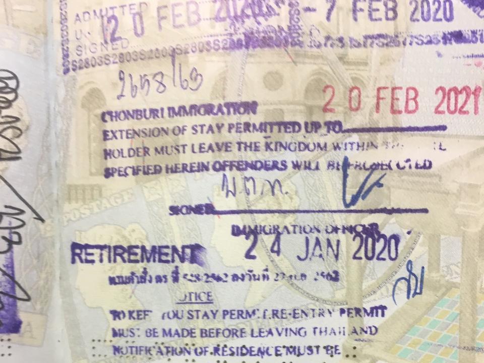


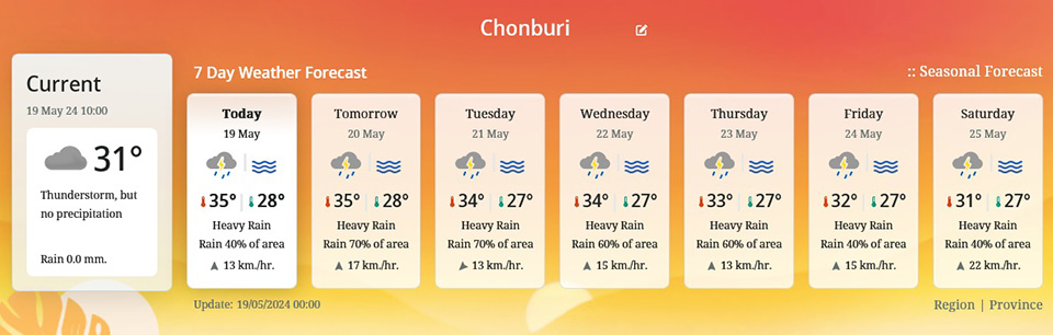
The Meteorological Department reports that upper Thailand will experience thunderstorms and strong winds in some areas, with heavy rain expected in the northern and central regions, including Bangkok and its vicinity, as well as the eastern region. The southern region will also have heavy rain in some areas. A warning has been issued for increased rainfall across Thailand with heavy rain in some areas from May 22-26.
The 24-hour weather forecast predicts that the southwest wind will cover upper Thailand, which will experience hot weather during the day. Additionally, a low-pressure area covering northern Vietnam will cause thunderstorms, strong winds in some areas, and heavy rain in the northern and central regions, including Bangkok and its vicinity, and the eastern region. Residents in these areas should be cautious of thunderstorms, strong winds, and heavy rain that may occur. Meanwhile, the southwest wind covering the Andaman Sea, the southern region, and the Gulf of Thailand, along with a low-pressure area covering Sumatra, will continue to bring heavy rain in some areas of the southern region. Residents in the southern region should be cautious of heavy rain.
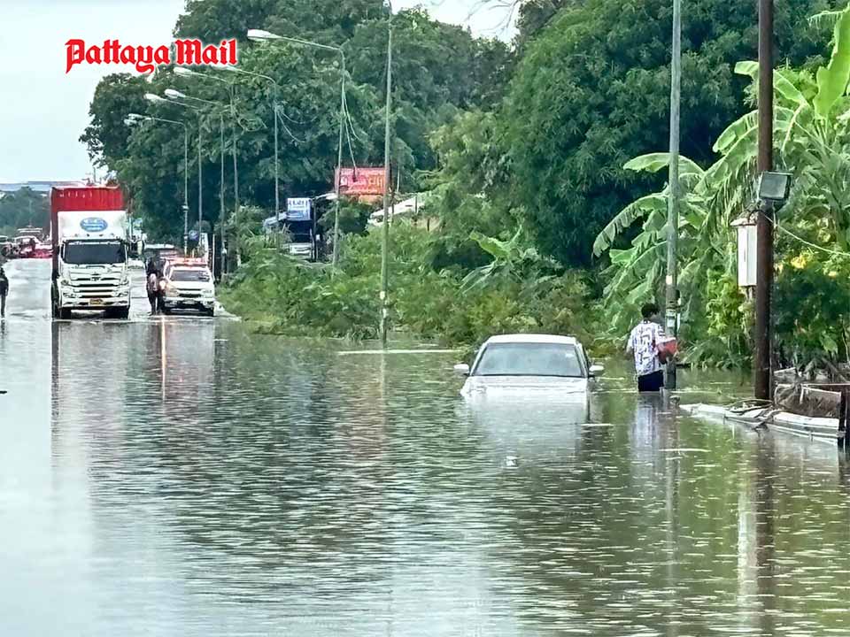
From May 20-23, the southwest wind covering the Andaman Sea, Thailand, and the Gulf of Thailand will strengthen. Additionally, from May 22-26, a low-pressure area covering the Bay of Bengal, Myanmar, is expected to intensify. This will lead to increased rainfall across Thailand with heavy rain in some areas, particularly in the western parts of the northern and central regions, and the western coast of the southern region. Residents across Thailand should be cautious of heavy to very heavy rain and accumulated rainfall that may cause flash floods and forest runoff, especially in foothill areas near waterways and low-lying areas. Increased caution is also advised for those traveling through areas with thunderstorms.
For the Andaman Sea and the Gulf of Thailand, waves are expected to intensify, with waves in the upper Andaman Sea reaching 2-3 meters and over 3 meters in thunderstorm areas. The lower Andaman Sea will see waves around 2 meters high, with over 2 meters in thunderstorm areas. The Gulf of Thailand will have waves around 1 meter high, and 1-2 meters offshore, with over 2 meters in thunderstorm areas. Mariners in the upper Andaman Sea should avoid sailing, while those in the lower Andaman Sea and the Gulf of Thailand should navigate with caution and avoid areas with thunderstorms.
Northern Region: Hot during the day with thunderstorms in 40% of the area, strong winds, and heavy rain in some areas, particularly in Mae Hong Son, Chiang Mai, Chiang Rai, Phrae, Nan, Lamphun, Lampang, Uttaradit, Tak, Kamphaeng Phet, and Phetchabun. Minimum temperature 24-28°C, maximum temperature 35-39°C. Southwesterly winds 10-15 km/h.
Northeastern Region: Hot during the day with thunderstorms in 40% of the area and strong winds in some areas, especially in Loei, Nong Khai, Bueng Kan, Sakon Nakhon, Nakhon Phanom, Chaiyaphum, Amnat Charoen, Nakhon Ratchasima, Buriram, Surin, Si Sa Ket, and Ubon Ratchathani. Minimum temperature 23-27°C, maximum temperature 33-37°C. Southwesterly winds 10-20 km/h.
Central Region: Hot during the day with thunderstorms in 60% of the area, strong winds, and heavy rain in some areas, particularly in Nakhon Sawan, Uthai Thani, Lopburi, Saraburi, Suphanburi, Phra Nakhon Si Ayutthaya, Kanchanaburi, Ratchaburi, Nakhon Pathom, Samut Sakhon, and Samut Songkhram. Minimum temperature 25-27°C, maximum temperature 35-38°C. Southwesterly winds 10-25 km/h.
Eastern Region: Thunderstorms in 60% of the area, strong winds, and heavy rain in some areas, particularly in Prachinburi, Sa Kaeo, Chachoengsao, Chonburi, Rayong, Chanthaburi, and Trat. Minimum temperature 24-27°C, maximum temperature 32-37°C. Southwesterly winds 15-30 km/h. Sea waves about 1 meter high, over 2 meters in thunderstorm areas.
Southern Region (East Coast): Thunderstorms in 60% of the area and heavy rain in some areas, particularly in Phetchaburi, Chumphon, Surat Thani, Nakhon Si Thammarat, Phatthalung, Songkhla, Pattani, Yala, and Narathiwat. Minimum temperature 23-27°C, maximum temperature 32-36°C. Southwesterly winds 15-30 km/h. Sea waves about 1 meter high, over 2 meters in thunderstorm areas.
Southern Region (West Coast): Thunderstorms in 70% of the area and heavy rain in some areas, particularly in Ranong, Phang Nga, Phuket, Krabi, Trang, and Satun. Minimum temperature 24-26°C, maximum temperature 32-35°C. Southwesterly winds 15-30 km/h. Sea waves about 1 meter high, over 2 meters in thunderstorm areas.
Bangkok and Surrounding Areas: Thunderstorms in 60% of the area with strong winds and heavy rain in some areas. Minimum temperature 26-28°C, maximum temperature 33-36°C. Southwesterly winds 10-30 km/h.